In recent years, there has been increased interest in the use of small uncrewed aircraft systems (UAS) for atmospheric science. These platforms and the sensors they carry have advanced to provide accurate, high-resolution measurements of atmospheric phenomena of interest across a wide range of environmental regimes, and in environments that are otherwise challenging, monotonous, expensive, or dangerous to sample. Through this course, participants will become more familiar with UAS and will be able to consider how to use them in their own work.
Introduction to Uncrewed Aircraft Systems (UAS) for Atmospheric Science
Image
Introduction
Course Overview
Micro-credential Option
Participants seeking a microcredential from the University of Colorado Boulder for completing this asynchronous course should submit their answers to the assessment questions embedded throughout the course by completing this Google Form. Please email ceee@colorado.edu when you have submitted your form.
Who is this for?
- College students interested in how to use UAS for atmospheric research
- Anyone who has interest in making a track 1, 2, or 3 NSF FIRP proposal and external agencies interested in working with the Mobile Uncrewed Systems for Atmospheric Science (MUSAS) at CU, Boulder
- Researchers interested in using UAS methodology for their studies
Objectives
Through this course, participants will:
- Understand the UAS that CU (MUSAS and IRISS specifically) have available along with their capabilities, limitations, and requirements for use.
- Describe what types of data that can be collected with UASs and how that data could be used.
- Explain how UAS could be used in different research projects.
- Understand how to work with MUSAS and IRISS
Format
This is a video-based asynchronous course. In the lessons, participants will watch videos, read the accompanying text and graphics, and take a short assessment to test learning.
Lesson Overview
The first four lessons will take between 15-25 minutes each and the case study review should take between 30-45 minutes for a total of approximately 2 hours.
Lesson one- Introduction to UAS research at CU Boulder
Lesson two- Overview of MUSAS platforms and equipment
Lesson three- Rules of the Sky (FAA rules and regulations)
Lesson four- Fun with FARE and FIRP (MUSAS position in NSF)
Lesson five- Case studies
Selected acronyms used in this course
A quick reference guide to key terms and organizations featured in this course.
Instructors & Partners
Thank you to all who contributed!
Lesson One: Introduction to UAS research at CU Boulder
Introduction to the Integrated Remote and In-Situ Sensing (IRISS) at CU, Boulder
This video was filmed in 2017 at the beginning of the Integrated Remote and In-Situ Sensing (IRISS) project at CU, Boulder. Begin by watching this to consider a few of the ways drones were used in the early days of the project. IRISS has conducted multiple research projects since the project began. Explore a few of the recent projects here.

Assessment
Why use drones?
What does IRISS stand for?
What are some of the recent areas of research IRISS has been involved in?
History of Drones at the University of Colorado, Boulder
In this video, Brian Argrow describes how drones have evolved into valuable tools for atmospheric research through his work at the University of Colorado, Boulder. He describes four eras that include significant milestones in drone research. While watching the video, note the events and projects of each era.
Assessment
Define the major features of each of these eras:
1995-2003 Early Years
2003-2007 Coalescence: Research and Engineering Center for Unmanned Vehicles (RECUV)
2007-2015 Building Partnerships, Maturing Technologies, and Leading Airspace Integration
2015-Present: IRISS, MUSAS, and Expanding Partnerships
Lesson Two: Overview of MUSAS platforms and equipment
MUSAS Platforms and Equipment
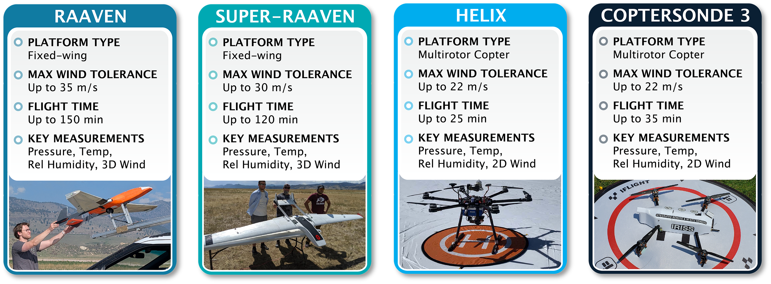
Melissa Wagner describes the UAS platforms used by MUSAS and the supporting equipment that enables teams to conduct research in the field. While watching this video, note the uses of each platform and what type of research each is best suited for.

Assessment
Which platform would be best suited for vertical flight with a significant payload?
Which platform can fly for over two hours?
Which platform is easiest to transport due to its size and weight?
Which platform has the largest wingspan?
In addition to multiple UAS platforms, which tools does MUSAS use to conduct field research?
Lesson Three: Rules of the Sky
UAS Rules of the Sky
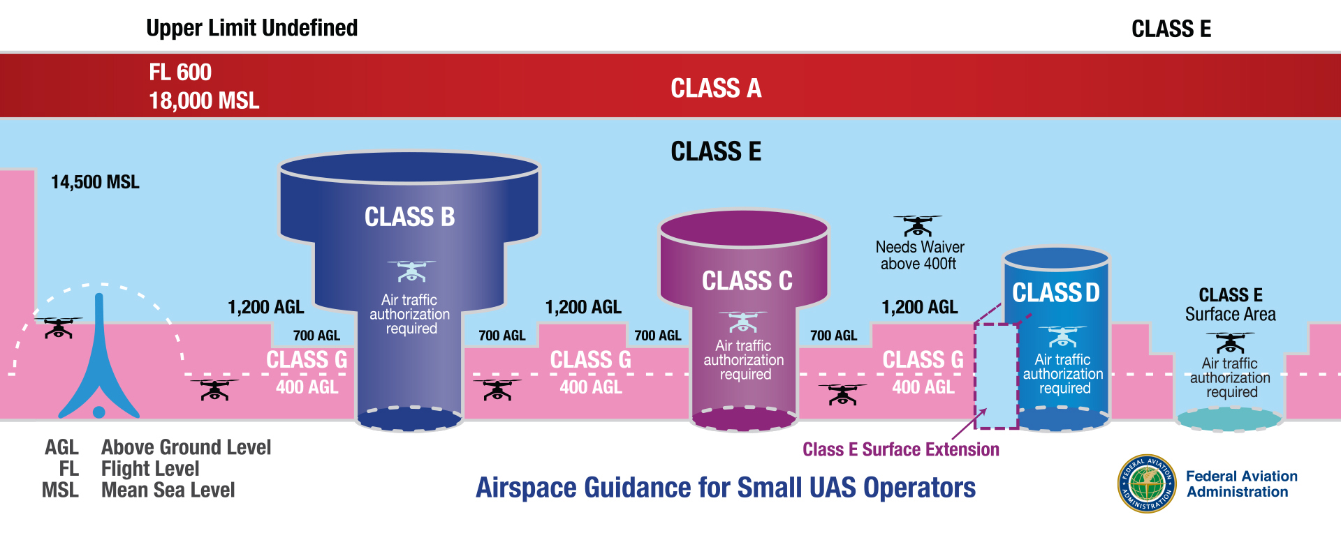
The FAA rules and regulations that govern how and where UAS operators can fly are described in this video by Brian Argrow. MUSAS and IRISS have been working with the FAA for decades to define the rules and exceptions for their UAS research. While watching this video, familiarize yourself with UAS guidance and the COAs MUSAS holds.

Assessment
What does it mean to operate as a class G UAS?
What is a COA?
Why might you need a COA?
Which section of the FAA rules governs UAS flight?
Lesson Four: Fun with FARE and FIRP
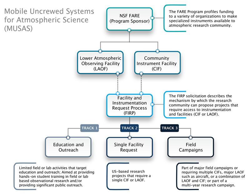
Understanding FARE and FIRP
This chart and accompanying video describe the process by which MUSAS makes its equipment available for research through NSF. Read through the chart, explore the links for the various chart sections, and watch the video to familiarize yourself with what it means for MUSAS to be part of the National Science Foundation Community Instruments and Facilities program.

Assessment
Explore the links on the diagram to answer the assessment questions:
What is the purpose of FARE?
What is the difference between LOAF and a CIF?
Do the following represent components of an LOAF or a CIF?
Why would I need a FIRP?
What are the three FIRP tracks?
Lesson Five: Case studies
Case Study Overview
These case studies describe research conducted by IRISS and MUSAS in the field. Project leaders from MoSAIC, ICECHIP, and TORUS‐LItE describe their work through the interviews below. Watch each video to understand the achievements, challenges, and research advancements each project achieved.
MUSAS MOSAiC Case Study
Project Multidisciplinary-drifting Observatory for the Study of Arctic Climate (MOSAiC) is a collaborative effort with CIRES, NOAA, and CU-Boulder’s Atmospheric and Oceanic Sciences and Aerospace departments. This project developed and deployed unmanned aircraft to operate at the farthest northern reaches of the planet to make critically needed measurements on the Arctic atmosphere and sea ice.
Sponsors: The project was led by Germany’s Alfred Wegener Institute (AWI), with key support from the U.S.’s Cooperative Institute for Research in Environmental Sciences (CIRES) at the University of Colorado Boulder and NOAA Earth System Research Laboratory’s Physical Science Division (PSD). The U.S. represents the second-largest national contribution with funding support from NOAA, NSF, DOE, and NASA.
Period of Performance: 2019-2020
Collaboration Principal Investigator: Gijs de Boer, currently with Brookhaven National Laboratory and previously a CIRES research scientist, collaborated with John Cassano of the Department of Atmospheric and Oceanic Sciences and CU Boulder aerospace engineering professors Dale Lawrence and Brian Argrow to fly drones to collect data on near-surface conditions.
In-situ Collaborative Experiment for the Collection of Hail In the Plains (ICECHIP)
This two-year field campaign was designed to close critical observational knowledge gaps in hail research by exploiting an almost entirely mobile observational fleet to ensure opportunistic sampling of convection wherever it occurs.
Sponsor: National Science Foundation, Award AGS 2410914
Period of Performance: 09/01/2024 - 08/31/2028
Collaboration Principal Investigator: Dr. Rebecca Adams-Selin, Atmospheric and Environmental Research, Inc.
Targeted Observations by Radars and UAS of Supercells Left‐flank‐Intensive Experiment (TORUS‐LItE)
TORUS-LItE provided a focused, single-field-season follow-on to TORUS that targets data collection using a subset of TORUS assets focused on the supercell left-flank.
Sponsor: National Science Foundation, Award AGS 2312996
Period of Performance: 05/01/2023 - 04/30/2026
Collaboration Principal Investigator: Dr. Adam Houston, University of Nebraska - Lincoln

Assessment
What is the MoSAIC project?
What does ICECHIP study?
What was learned during the TORUS project?