Land Surface Temperature - Arctic Blast
Temperature changes can reveal a lot about a location’s climate and landscape—especially in winter. On January 21, 2025, an Arctic Blast brought record-breaking cold to the Southern Gulf States, covering New Orleans, LA, in an astonishing 8 inches of snow! In this activity, students will explore this rare event and compare it to the hottest day of 2024, looking for patterns and clues about temperature extremes.
Context for Use
In this short activity, students will strengthen their critical thinking skills by carefully observing the data, forming ideas, and backing them up with evidence.
While these maps connect to lessons on weather, climate, climate zones, and topography, the main focus is on slowing down, looking closely, asking great questions, and building stronger evidence-based ideas. If you’re teaching any of these topics, this activity could be a valuable addition to your unit!

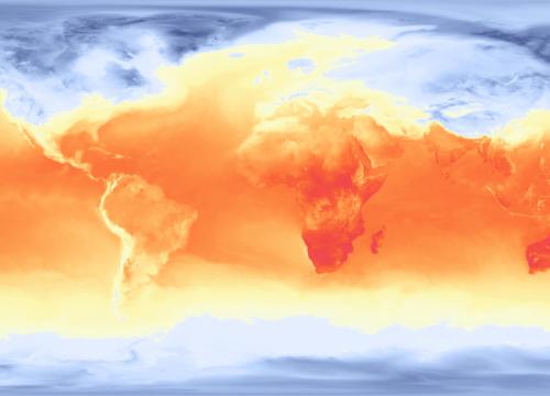
Land Surface Temperature of the Americas in Fahrenheit.
Goals Header
What Students Will Do
- Students will strengthen their critical thinking skills by carefully observing the data, forming ideas, and backing them up with evidence.
Teaching Materials
- Students enhance their ability to observe deeply and make sense of complex data.
Description
Time required: 10-20 minutes
