Adapting to Extremes: Exploring the Science of Floods in Colorado
The way we choose to design our communities has impacted community risk and vulnerability to flooding; in this lesson, students will explore this concept by analyzing environmental data to classify patterns and practice communicating their findings.
Context for Use
This lesson is best used as part of the HEART Force curricular unit. Potential lessons to follow include:
This lesson could also be a stand-alone lesson to introduce students to flood in Colorado.

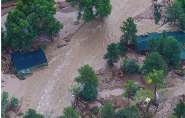
Aerial scene of Big Thompson Flood of 2013 along Hwy. 34
Photo Credit: U.S. Air National Guard, Capt. Darin Overstreet
Goals Header
What Students Will Do
- Analyze flood data to identify patterns of flood history and risk in Colorado.
- Communicate information about historic causes and effects of floods in your community. Explain what community members should do to be safe in the event of a flood.
Materials
User note: To make an editable copy of the teaching materials in Google Drive, select File > “Make a copy”. This will make a copy for you to save to your own drive and edit as you see fit.
Description
Students will build understanding about floods in Colorado through the following learning activities:
- Part 1 – Engage (20 minutes) Introduction to Flood Concepts and Case Study
As a class, watch news clips about floods in Colorado and have a brief class discussion.
- Part 2 – Explore (60 minutes) Flood Data Analysis Jigsaw
In groups, analyze flood information and data to build understanding of the causes, impacts, locations, and frequency of floods. Additionally, students use GIS to identify areas in their community in the 100 year floodplain that may be at risk of flooding.
- Part 3 – Explain and Evaluate (90 minutes) Community Outreach for Flood Preparation
New student groups (with a student from each group in Activity 2 jigsaw) will present information to each other, and begin writing an outline for a Letter to the Editor. Next, students write a Letter to the Editor answering the driving question: What can we learn from past flood events to prepare for future floods?


